
Introduction
A Ground Settlement Impact Assessment predicts construction-induced ground movements and systematically evaluates how those movements affect adjacent buildings, utilities, and other sensitive infrastructure. In Singapore’s densely built urban environment, GSIA is a mandatory component of BCA authority submissions for deep excavations, tunnelling, basement works, and any project where excavation activities can induce ground settlements affecting nearby structures.
This guide covers Singapore-specific regulatory requirements under BCA, PUB, and LTA frameworks, the Burland damage classification system and its application criteria, utility deformation limits, and settlement trough calculation methods used in submission documents. It does not address overseas standards or codes. The target audience includes structural engineers, project managers, developers, and consultants preparing authority submissions for excavation projects near sensitive structures in Singapore.
GSIA quantifies potential building damage and utility deformation using established criteria like the Burland classification system and PUB guidelines, enabling engineers to demonstrate construction compliance and protect adjacent structures from unacceptable risk.
Key outcomes from this guide:
-
Understanding the Burland damage classification system (Categories 0–5) and how to apply it in Singapore submissions
-
Mastering settlement trough calculation methods and influence zone determination
-
Learning PUB and SPPG utility deformation limits for comprehensive assessments
-
Preparing compliant BCA, PUB, and LTA authority submissions with correct documentation
-
Implementing effective monitoring protocols and mitigation measures for adjacent sensitive structures
Understanding Ground Movement and Settlement Impact Assessment Fundamentals
GSIA is the engineering analysis that evaluates how construction-induced ground movement-including total settlement, differential settlement, tilt, angular distortion, and horizontal strain-affects existing buildings and underground utilities. It is used to assess soil and structural stability around urban excavation works, with key factors including total settlement and the structural conditions of buildings within the zone of influence. Typical GSIA deliverables include geological models, risk assessments, and mitigation recommendations.
Ground Settlement Impact Assessments are critical for urban construction activities like tunneling and deep excavations, particularly in Singapore where dense development means that virtually every major project has adjacent structures within the settlement influence zone. The regulatory framework under the BCA Building Assessment Framework requires engineers to demonstrate that predicted ground settlement remains within allowable limits before construction approval is granted.
Settlement Mechanisms and Causes
Ground settlement in Singapore civil engineering projects arises from three primary mechanisms: immediate (elastic) settlement during soil removal, consolidation settlement as excess pore water pressures dissipate in soft clay, and secondary compression (creep) over extended periods. Singapore’s Kallang Formation marine clay-with undrained shear strength as low as 10–30 kPa in the upper layers and coefficient of consolidation (c_v) of approximately 0.47–0.6 m²/year-makes these mechanisms particularly significant.
Excavation activities can cause permanent soil deformations through several pathways. Support-of-excavation systems limit ground settlement severity, but lateral wall deflection still transfers ground movement to the surrounding soil mass. Groundwater dewatering can cause significant soil settlements, sometimes exceeding excavation-induced settlement itself. The presence of groundwater can induce consolidation settlement that extends well beyond the project area-a phenomenon observed in Singapore where under-drainage of marine clay through the underlying Old Alluvium has caused substantial long-term settlement. Groundwater seepage through permeable strata beneath soft clay layers compounds these effects.
Sensitive Structure and Adjacent Buildings Categories
Geotechnical investigations identify soil layering, groundwater, and shear strength to assess risks, but equally important is classifying the structures within the zone of influence. Under the BCA framework, sensitive structures fall into distinct groups:
-
Group 1 (High Sensitivity): Conserved buildings, dilapidated structures, and buildings with pre-existing damage or mixed foundations. The risk of structural damage is higher for buildings identified as heritage or sensitive. These are limited to 10 mm total building settlement under the Deemed-to-Satisfy approach.
-
Group 2: Standard buildings on pile or shallow foundations, minor structures. Shallow foundation portions allow up to 25 mm; pile foundation portions up to 15 mm total settlement.
-
Utilities and Infrastructure: Water mains, sewer systems, telecommunications conduits, and transit structures requiring separate deformation criteria.
Structural sensitivity to ground movements varies by material properties, foundation type, and age. Engineers must evaluate foundation types to understand the response to ground movements-a building on shallow foundations responds very differently from one on deep piles. For mixed foundation buildings, the interface between shallow and piled portions creates concentrated differential settlement risk.
Understanding these categories directly feeds into the damage classification systems used to assess whether predicted movements are acceptable.
Building Damage Classification and Assessment Criteria
With settlement mechanisms and structure categories established, the next stage of a GSIA is classifying the predicted damage level for each affected structure. This classification determines whether the project can proceed under normal conditions, requires additional mitigation, or demands a redesign of the temporary works and ERSS.
Burland Damage Classification System
The Burland/Boscardin & Cording damage classification system, adopted in Singapore’s TR-26 Deep Excavation Technical Reference, provides a quantitative framework linking ground movement to building damage severity. Engineers compare predicted movements to established damage criteria to classify risks across six categories:
|
Damage Category |
Description |
Limiting Tensile Strain (ε_lim) |
Typical Crack Width |
Practical Implication |
|---|---|---|---|---|
|
0 – Negligible |
Hairline cracks only |
< 0.05% |
< 0.1 mm |
Cosmetic; no action required |
|
1 – Very Slight |
Fine cracks, easily treated |
0.05–0.075% |
Up to ~1 mm |
Cosmetic repair only |
|
2 – Slight |
Cracks noticeable, doors may stick |
0.075–0.15% |
Up to ~5 mm |
Serviceability concern |
|
3 – Moderate |
Moderate cracks, possible pipe fracture |
0.15–0.30% |
5–15 mm |
Requires remedial work |
|
4/5 – Severe/Very Severe |
Extensive cracking, structural instability risk |
> 0.30% |
> 15 mm |
Risk to structural integrity and safety |
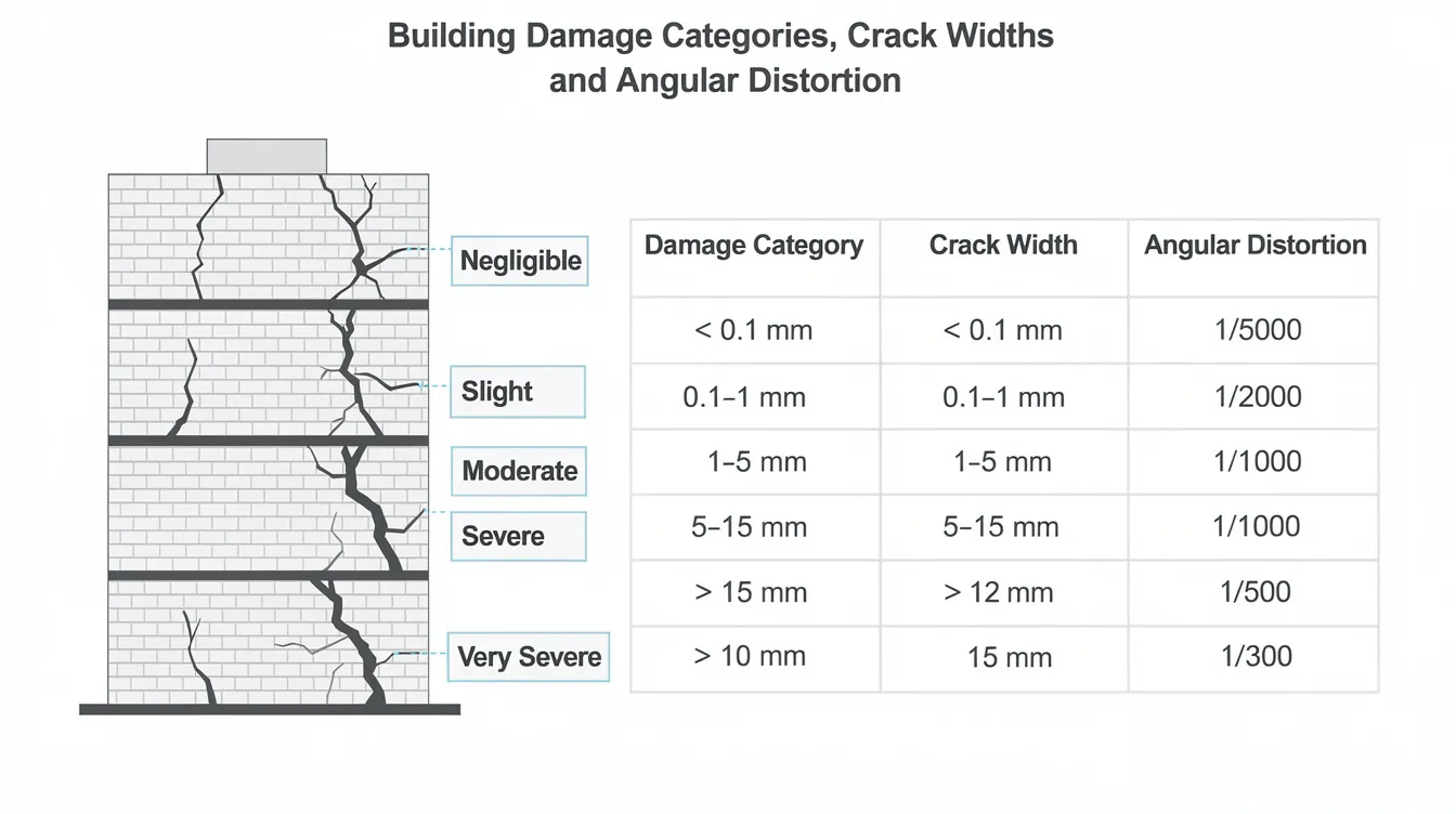
Differential settlement and angular distortion are critical in assessing structural safety. Angular distortion (δ/L) exceeding 1/500 generally corresponds to “Slight” or worse damage categories for masonry buildings. Engineers assess soil-structure interaction to determine how buildings respond to ground movement-a stiff reinforced concrete frame redistributes settlement differently than a load-bearing masonry wall. Buildings near excavation sites can experience a maximum settlement value of up to 15 mm in typical Singapore conditions, though extreme cases in unfavorable soil layering have recorded values of 2.6% of the excavation depth.
For BCA’s Deemed-to-Satisfy approach, predicted movements must remain within the “Very Slight” damage category or better for sensitive structures.
PUB and SPPG Utility Deformation Limits
Ground movement can affect nearby buildings, utilities, and other sensitive infrastructure. Utility deformation assessment is often overlooked but is equally critical in GSIA submissions. PUB’s Code of Practice for Sewerage & Sanitary Works requires that pipe gradients, joint integrity, and connection alignments are maintained throughout construction.
Key utility deformation considerations include:
-
Sewer pipes with jointed connections: Particularly sensitive to differential settlement; allowable angular deflection at joints is typically limited to prevent blockage and leakage. Industry practice generally aligns with a slope differential limit of approximately 1:1,000 to avoid joint failure.
-
Water mains: Must maintain pressure integrity; bending and shear deformation limits are determined by pipe material and diameter.
-
Telecommunications and power conduits: Sensitive to lateral displacement and differential settlement between support points.
PUB’s recently published Code of Practice on Coastal Protection (first edition June 2026, effective 2028) explicitly mandates that displacement, settlement, cracking, and vibrations must remain within acceptable Serviceability Limit State values-including effects on utilities within coastal protection zones. Submissions must include PE(Civil)-endorsed analyses demonstrating compliance.
For comprehensive GSIA preparation, utility owners must be consulted early to confirm specific deformation limits applicable to their assets within the settlement influence zone.
Singapore Authority Requirements
BCA requires that GSIA submissions demonstrate compliance with allowable settlement figures that vary by building group and foundation type:
|
Building / Foundation Type |
Allowable Total Settlement |
Allowable Differential / Tilt |
Conditions |
|---|---|---|---|
|
Group 1 sensitive buildings |
Up to 10 mm |
≤ 1:500 |
Conserved, dilapidated, or mixed-foundation buildings |
|
Group 2 – shallow foundation |
Up to 25 mm |
≤ 1:500 |
Standard buildings on shallow foundations |
|
Group 2 – pile foundation |
Up to 15 mm |
≤ 1:500 |
Standard buildings on piles |
|
Mixed foundation interface |
Shallow: 25 mm / Pile: 15 mm |
Interface differential ≤ 1:500 |
Updated in 2024 BCA circulars |
|
Raft foundation (low risk) |
Up to 25 mm |
≤ 1:500 |
Standard conditions |
|
Raft foundation (medium/high risk) |
Up to 30 mm |
≤ 1:500 |
Requires enhanced monitoring and contingency |
|
LTA transit zones – shallow foundation |
20 mm (short & long term) |
≤ 1:1,000 |
|
|
LTA transit zones – deep foundation |
15 mm (short term), 25 mm (long term) |
≤ 1:1,000 |
Deep Foundation Elements in railway protection zones |
Recent BCA circulars (2024) updated the Deemed-to-Satisfy limits, particularly clarifying the interface differential settlement requirement of 1:500 for mixed foundation buildings. These updates reinforce the need to present separate settlement predictions for shallow and pile portions of mixed-foundation structures.
With damage classification criteria and allowable limits established, the next step is understanding the calculation procedures and settlement analysis methods required for compliant submissions.
GSIA Calculation Procedures and Settlement Analysis
The technical core of any GSIA submission lies in the settlement analysis—predicting the magnitude, extent, and distribution of ground settlement, then converting those predictions into usable design and planning function outputs and damage classifications for each affected structure.
Settlement Trough Calculation Method
Settlement trough models describe the ground surface settlement profile used in tunnel excavation and excavation-induced settlement analysis. For tunnelling, the widely used Gaussian trough model defines the settlement at any distance from the tunnel centreline using maximum settlement (S_max) and trough width parameter (i), where i = k × H (k typically ranges from 0.5 to 1.0 depending on soil stiffness, and H is the tunnel depth). Settlement Limit Curves help determine safe ground settlement levels by mapping the predicted trough against allowable limits for each adjacent structure.
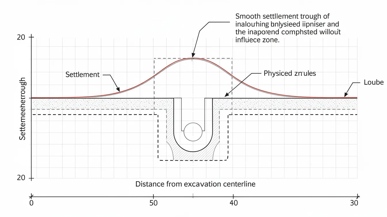
For basement excavations, empirical data from Singapore case studies provides useful examples showing that the influence zone can extend remarkably far. In one documented case study of excavation in marine clay underlain by dense silty sand, the zone of influence extended to 11 times the maximum excavation depth. With an 11.5 m excavation depth, ground settlement as large as 2.6% of the excavation depth was observed at that extended zone.
Numerical modeling predicts surface settlements from tunneling activities and excavation works with significantly greater accuracy than empirical methods alone. Numerical simulations can predict construction-induced ground movements using finite element analysis, an advanced analysis technology, in software such as Plaxis, employing advanced constitutive models like Hardening Soil or Soft Soil Creep that capture the nonlinear behaviour of Singapore’s marine clay. Engineers have developed project-specific numerical models to predict settlement response under different staging and soil conditions. Finite element analysis assesses building response to induced settlements by modelling soil structure interaction directly.
The rigorous settlement analysis procedure follows these steps:
-
Geotechnical parameter collection: Compile field data from site investigation-boreholes, vane shear, cone penetration tests, oedometer consolidation tests-to establish soil model parameters. Material properties including modulus, c_v, undrained shear strength, and sensitivity must be derived from local test data and calibrated against published ranges for the Kallang Formation.
-
Excavation geometry and staging definition: Model the excavation depth, sequence, and earth retaining systems. Common earth retaining systems include sheet piling and soldier piles, along with diaphragm walls for deeper excavations. The design of earth retaining systems is influenced by nearby building damage criteria-more sensitive adjacent structures demand stiffer support systems.
-
Settlement trough modelling: Generate predicted settlement profiles using empirical Gaussian curves for preliminary assessment or numerical FEM for rigorous analysis. Parameter variations should be analyzed to understand how soil stiffness, permeability, and wall stiffness affect predicted settlements.
-
Influence zone determination: Map the settlement trough onto site plans to identify all structures within the zone of influence. Account for three-dimensional effects, particularly at excavation corners and where geometry varies.
-
Building response calculation: For each affected structure, calculate angular distortion, differential settlement, horizontal tensile strain, and tilt. Compare these to the Burland damage classification thresholds and Settlement Limit Curves to classify the predicted damage category.
The City Square Mall project in Singapore is another of those examples illustrating the importance of rigorous modelling. This 18 m deep excavation in very soft marine clay with ground improvement showed that observed wall movements and ground settlements were much less than initially estimated. However, FEM back-analyses demonstrated that only 3D modelling could capture the deflected wall shape accurately-confirming that assumptions of constant modulus and linear soil behaviour can underestimate risks when the geometry is complex, and that shape is typically presented in a figure in technical reports.
For stacked tunnelling in the Kallang Formation, research has used Monte Carlo methods and back-analysis of simulated data to calibrate empirical trough parameters against monitored field data, producing more reliable predictions for future tunnel construction stages.
Authority Submission Documentation Requirements
A compliant GSIA submission must contain specific documentation tailored to the reviewing authority. The table below compares requirements across BCA, PUB, and LTA:
|
Requirement |
BCA Submission |
PUB Submission |
LTA Submission |
|---|---|---|---|
|
Calculation methods |
Deemed-to-Satisfy or Rigorous (FEM with SSI) |
PE(Civil)-endorsed analysis |
Compliance with E/GD/09/106/A2 |
|
Supporting drawings |
As-built foundation & superstructure drawings |
Utility layout and connection details |
Track alignment and structure proximity plans |
|
Settlement predictions |
Trough plots, predicted vs time profiles |
Deformation at utility crossings |
Settlement contours within protection zone |
|
Monitoring plan |
Settlement markers, inclinometers, piezometers |
Utility displacement monitoring |
Real-time monitoring with alert systems |
|
Damage classification |
Burland categories with strain/crack mapping |
Functional performance criteria |
Allowable settlement per foundation type |
|
Mitigation measures |
Ground improvement, compensation grouting, underpinning |
Pipe protection, rerouting plans |
Contingency for trigger level exceedance |
For the Rigorous Approach under BCA, submissions must include detailed soil-structure interaction modelling, structural capacity assessments for predicted cracks, and clearly stated assumptions. The analysis model must demonstrate accuracy through calibration against comparable case study data or published research for Singapore soil conditions. The calculation report should also state the basis on which the analytical framework was construct ed.
Engineers should present settlement trough plots showing the predicted profile overlaid with building footprints, cross-sections illustrating the soil profile with the excavation geometry and predicted displacement contours, and time-dependent settlement curves where consolidation is significant. Monitoring plans should also identify where instruments or support elements are installed on the relevant drawings. A thorough pre-construction condition survey of all buildings within the influence zone provides the baseline against which predicted and measured movements are assessed. A technical paper or published Singapore case reference may be cited where it directly supports modelling assumptions or calibration.
Common Assessment Challenges and Solutions
Even experienced practitioners encounter difficulties in GSIA preparation. Understanding these challenges and their solutions improves submission quality and reduces the risk of rejection.
Inadequate Geotechnical Data
Incompetent or sparse site investigation data can produce settlement predictions that are off by an order of magnitude-particularly when critical soil layering (such as a stiff stratum beneath soft clay) is not captured. In Singapore’s marine clay, where the upper clay has sensitivity values of 3 to 8, accurate parameter determination is essential.
Solution: Supplement existing data with additional boreholes and in-situ testing targeted at the critical soil layers beneath and adjacent to the excavation. Where data gaps remain, adopt conservative assumptions and present the parameter sensitivity analysis showing the range of possible outcomes. Document all assumptions explicitly so that the reviewing authority can evaluate the safety margin effectively. For projects where the site investigation reveals complex layering, the BCA’s Guide on Ground Investigation provides requirements for characterizing ground conditions to Eurocode 7 standards.
Complex Building-Soil Interaction
Many older buildings in Singapore have unknown foundation types or mixed foundations combining shallow footings and piles. Without as-built drawings, predicting how these structures respond to ground movement introduces significant uncertainty. The maximum vertical settlement difference between buildings on different foundation types was recorded at 12.3 mm in documented cases, highlighting how interface differential settlement concentrates at foundation transitions.
Solution: Commission a structural inspection and non-destructive testing to determine foundation type where records are unavailable. For mixed foundations, model the shallow and pile portions separately, calculating the interface differential explicitly. Use conservative stiffness assumptions for the building superstructure in the soil structure interaction model. Where foundation details remain uncertain, default to Group 1 (high sensitivity) classification with the more restrictive 10 mm allowable settlement.
Authority Submission Rejections
Common rejection reasons include missing as-built structural drawings, incomplete damage classification mapping, insufficient monitoring plans, or predicted movements that exceed allowable values without adequate mitigation measures identified.
Solution: Prepare submissions as complete packages from the outset. Include the full damage classification mapping for every structure within the identified influence zone-not just the nearest building. Ensure the monitoring plan specifies instrument types (a comprehensive monitoring plan includes instruments like inclinometers and settlement markers), frequencies, trigger and alarm levels, escalation hierarchy, and responsible parties. Real-time monitoring during construction helps verify predictions and manage risks. Peak particle velocity is used to assess potential vibration damage and should be included in monitoring programs alongside settlements. Engage qualified person supervision early and consider a peer review through an Accredited Checker for complex projects before submission.
Monitoring Program Design and Implementation
A robust monitoring program validates predictions and provides early warning when movements approach or exceed trigger levels. Seventeen surface settlement monitoring points were established in a documented Singapore metro station project, with vertical displacement monitoring points set up at six locations. Maximum surface settlement values were controlled within 2 mm during excavation through effective real-time monitoring and responsive construction management. Monitoring programs should include vibrations and settlements during construction to provide complete data for ongoing risk evaluation.
Mitigation measures may include ground improvement techniques, underpinning, and monitoring adjustments-implemented at different trigger levels as determined by the GSIA. Earth retaining systems minimize damage during excavation activities, but their performance must be verified through the monitoring program throughout every construction stage.
Conclusion and Next Steps
Ground Settlement Impact Assessments are the critical link between construction ambition and structural safety for adjacent sensitive structures in Singapore. A well-executed GSIA integrates geotechnical analysis, Burland damage classification, utility deformation evaluation, and settlement trough modelling into a cohesive submission that satisfies BCA, PUB, and LTA requirements while protecting existing buildings and infrastructure.
Key conclusions and next steps to move forward effectively on your project:
-
Conduct a preliminary assessment to identify all structures and utilities within the potential settlement influence zone and classify their sensitivity
-
Commission adequate site investigation to characterize soil conditions, particularly the depth and properties of Singapore’s marine clay layers
-
Engage qualified geotechnical and structural consultants experienced in Singapore’s regulatory framework to perform the settlement analysis and damage classification
-
Prepare authority submissions with complete documentation-calculation reports, as-built drawings, monitoring plans, and contingency measures
-
Implement the monitoring program before construction begins and maintain it through all stages of excavation
Related topics that support a comprehensive GSIA include building defect investigation for pre-existing conditions, temporary works design for ERSS to control ground movement at the source, and periodic structural inspections for ongoing building integrity verification after construction completion.
Additional Resources
-
BCA Building Assessment Framework – Detailed requirements for ERSS impact assessments and Deemed-to-Satisfy vs Rigorous approaches
-
BCA Approved Document Guide – Comprehensive overview of Singapore’s building control standards
-
PUB Approval Requirements – Guide to PUB submission processes for sewerage and drainage works
-
LTA Civil Design Criteria E/GD/09/106/A2 – Allowable settlement and deformation limits within railway protection zones
-
TR-26 Deep Excavation Technical Reference (2010) – Damage classification tables, monitoring requirements, and trigger level frameworks for deep excavation projects in Singapore; useful applied geotechnical science for GSIA practice